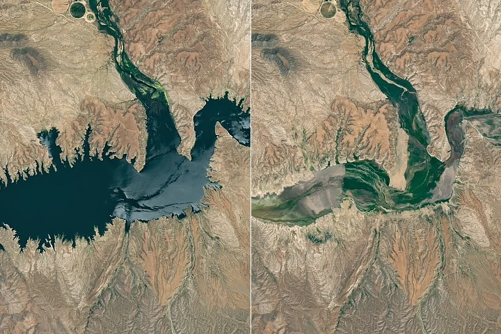
Arizona’s San Carlos Reservoir, formed by the Coolidge Dam on the Gila River, experienced drastic water level depletion in 2026 due to drought and mandated water releases. Confirmed by NASA Earth Observatory satellite imagery, the reservoir was nearly empty by late May, leading to a catastrophic fish kill and closure announced in early June.
What Happened
In 2026, the San Carlos Reservoir dropped to less than 1 percent of its capacity after minimal snowpack in the Gila River watershed and mandatory water releases for agriculture. NASA Earth Observatory’s Landsat images from May 22, 2026, documented the reservoir holding only 389 acre-feet of water. By June 5, 2026, officials ordered the reservoir closed indefinitely after hypoxic conditions caused the death of nearly all fish species in the reservoir.
Key Facts
- San Carlos Reservoir is created by the Coolidge Dam on the Gila River in Arizona.
- In May 2026, reservoir capacity was under 1 percent, holding approximately 389 acre-feet of water.
- The mountain snowpack at the Gila River headwaters was just 2 percent of the 1991–2020 March median.
- Streamflow in April 2026 was measured at 39 percent of normal.
- Fish species impacted included largemouth bass, black crappie, bluegill, channel catfish, flathead catfish, brown trout, and rainbow trout.
- The reservoir has previously experienced similarly low levels at least 20 times since 1930.
- The closure followed fish deaths caused by low oxygen (hypoxia) in the water.
Why It Matters
The reservoir is a critical water source for agricultural irrigation, wildlife, and recreation in southwestern Arizona. The near depletion and fish die-off highlight the severe impact of prolonged drought and water management demands in the southwestern United States. The environmental damage affects ecosystem health and local livelihoods relying on the reservoir.
Background
The Gila River, one of the Southwest’s key rivers, is fed by snowmelt from the Mogollon Mountains and Black Range in New Mexico. The Coolidge Dam, completed in 1930, forms the reservoir, which is one of Arizona’s largest water bodies when full. Historic droughts and low water levels have periodically affected the reservoir since then, including major fish kills in 1976 and 2018. Will Rogers famously joked about the dry reservoir at its dedication in 1930, noting grass growing on the lakebed.
Analysis
NASA and U.S. Geological Survey data attribute the low reservoir levels chiefly to the exceptionally poor winter snowfall and drought conditions in the Gila River watershed. Mandatory water releases for downstream farming needs further reduced water levels. NOAA’s seasonal outlook noted an increased chance of rain in summer 2026 due to a strengthening El Niño event, which could help recovery.
Who Is Affected
Farmers relying on reservoir water for irrigation, local wildlife dependent on aquatic habitats, recreational users such as anglers and boaters, and regional water managers are directly impacted by the reservoir’s low water levels and fish die-off.
What Remains Unclear
- The full ecological recovery timeline remains uncertain, based on prior events such as the 1976 fish kill where it took five years to rebound.
- The extent of potential health risks associated with decomposing fish in the reservoir has not been fully assessed.
What Comes Next
Water managers and scientists are monitoring the reservoir’s status closely ahead of the 2026 monsoon season, which NOAA projects could bring above-average precipitation. Ongoing satellite and field observations will determine if inflows can replenish reservoir levels and aid ecosystem recovery.
Sources
This article is based on reporting and publicly available information from the following source:
Read more Science & Technology stories on Goka World News.