Engineers from the Massachusetts Institute of Technology (MIT) and the Woods Hole Oceanographic Institution (WHOI) have developed Sonar-MASt3R, a new underwater imaging system capable of mapping and visualizing environments in murky, low-visibility waters. Their work, led by MIT graduate student Amy Phung with co-author Richard Camilli of WHOI, was presented at the 2024 IEEE International Conference on Robotics and Automation (ICRA).
What Happened
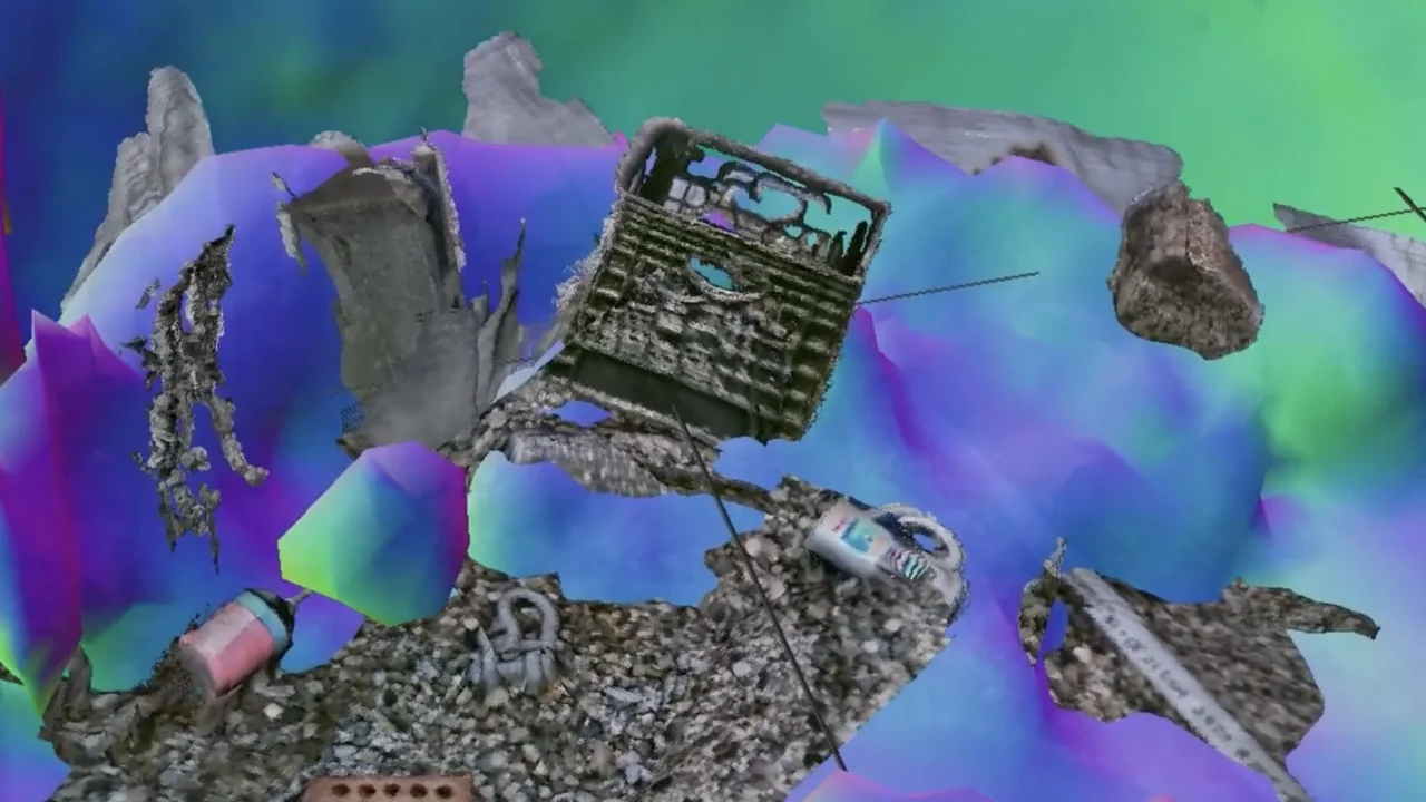
The researchers combined optical camera imagery with sonar sensor data to create a real-time, three-dimensional underwater mapping technique. This fusion approach allows remotely operated vehicles to navigate and inspect objects even when turbidity obscures optical vision. The method was tested in controlled tank experiments simulating various degrees of water cloudiness. Despite highly sedimented conditions, the system successfully generated coarse sonar maps and refined these with optical images to produce centimeter-scale detailed 3D reconstructions of objects like a boulder and a coffee mug.
Key Facts
- Study presented at the IEEE International Conference on Robotics and Automation (ICRA) in 2024
- Research institutions: Massachusetts Institute of Technology (MIT) and Woods Hole Oceanographic Institution (WHOI)
- System name: Sonar-MASt3R, building on the existing MASt3R algorithm
- Experiments conducted in controlled water tanks with eight turbidity levels
- Testing objects included small-scale items such as a boulder, coffee mug, and packing crate
- Supported partially by NASA and the National Science Foundation
Why It Matters
This imaging advance significantly extends underwater vehicle operational capabilities into turbid and sediment-heavy environments, which were previously inaccessible due to poor optical visibility. It offers potential improvements for scientific exploration, underwater construction, maintenance, and the safe recovery of submerged unexploded ordnance. By enabling accurate, real-time mapping, it opens new frontiers in underwater robotics and marine research.
Background
Prior underwater imaging efforts used either optical cameras, which provide detailed visuals but suffer in murky water, or sonar sensors, which can detect shapes and distances but lack visual detail. Some earlier opti-acoustic fusion methods sought to combine these inputs for object recognition but were limited by slow processing and lacked application in turbid underwater settings. Sonar-MASt3R advances this concept by integrating scaling from sonar with visual mapping from the MASt3R algorithm to create accurate 3D maps in real-time under challenging conditions.
Analysis
Amy Phung explained that sonar provides the absolute scale missing from optical depth estimates, enabling precise environmental mapping. Richard Camilli highlighted the method’s utility in safely locating underwater explosives in low-visibility areas, presenting a clear practical benefit. The analogy of navigating a china shop in the dark was used to illustrate how the system guides vehicles safely around objects without collateral damage.
Who Is Affected
This development benefits scientific researchers, underwater robotics operators, and agencies involved in mine clearance and marine infrastructure. It can enhance fieldwork in murky coastal zones, sediment-filled seabeds, and recovery operations where visibility is a major obstacle.
What Remains Unclear
- The system’s long-term performance and robustness in complex natural environments beyond controlled tank experiments
- Potential limitations in highly dynamic or biofouled underwater settings
- Operational integration with varied underwater vehicle platforms and broader ecosystems
What Comes Next
The researchers plan to test Sonar-MASt3R in natural underwater settings, where reverberation and echo effects are less pronounced than in tank “echo chamber” conditions. Successful field trials could lead to deployment in real-world scientific and operational missions where current imaging methods are inadequate.
Sources
This article is based on reporting and publicly available information from the following source:
Read more Science & Technology stories on Goka World News.