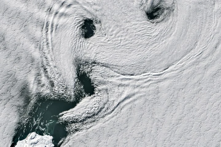
On a summer day in 2026, NASA’s Landsat 8 satellite recorded striking atmospheric features known as von Kármán vortex streets near Peter I Island, a remote ice-covered volcano off West Antarctica. These spiraling cloud patterns formed as prevailing winds interacted with the island’s terrain, revealing dynamic airflow over the Southern Ocean.
Vortex Formation Around Peter I Island
Peter I Island lies at 68.86 degrees south latitude in the Bellingshausen Sea, approximately 400 kilometers (250 miles) from the West Antarctic coast and over 1,800 kilometers (1,100 miles) from Cape Horn, Chile. The island’s volcanic presence disrupts the strong circumpolar winds circulating in this region, known to sailors as the Roaring Forties, Furious Fifties, and Screaming Sixties due to their intensity.
Von Kármán vortex streets are characterized by counterrotating spirals that form when airflow is forced around a barrier, then slows and spins into eddies. For these vortices to develop, wind speeds generally range from 18 to 54 kilometers per hour (11 to 34 miles per hour). Winds stronger than this tend to prevent the vortices from maintaining their shape.
The satellite images showed these alternating spirals of clouds extending downwind from Peter I Island, with the next day’s imagery revealing a complex mixture of cloud formations partially exposing the island’s icy surface. The island features a summit crater about 100 meters wide and rises 1,640 meters (5,380 feet) above sea level.
Scientific Context and Remote Location
Peter I Island is described by the Smithsonian Institution’s Global Volcanism Program as a “shield-like volcano,” though it has no recorded recent eruptions. The island was discovered in 1821 by Russian explorer Fabian Gottlieb von Bellingshausen but was not physically reached until 1929. Its remoteness and challenging sea ice conditions have limited extensive research.
Scientific studies on the island have focused on its geology, biodiversity, and climate history, including firn core sampling to understand past climate variability. In 2011, NASA’s airborne Operation IceBridge campaign flew over the region, collecting a range of polar ice measurements while its DC-8 aircraft captured rare aerial views of Peter I Island during transit back to Chile.
Why it matters
Understanding vortex formation over isolated Antarctic features like Peter I Island helps scientists study local wind patterns and their effects on weather and climate in the Southern Ocean. Documenting interactions between strong circumpolar winds and geographical barriers contributes to improving atmospheric models in a region critical for global climate regulation. The island’s isolation makes such satellite and aerial imagery particularly valuable for ongoing polar research.
Sources
This article is based on reporting and publicly available information from the following source:
Read more Space & NASA stories on Goka World News.