On May 8, 2026, satellites and seismometers detected a submarine volcanic eruption along the Titan Ridge in the Central Bismarck Sea, located about 16 kilometers southeast of a previous 1972 eruption site near Papua New Guinea. This underwater volcanic activity is occurring in a geologically complex and poorly mapped region characterized by deep ocean depths and tectonic activity.
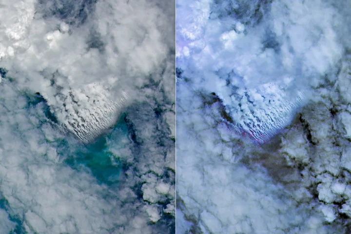
Seismic instruments recorded a small cluster of earthquakes on May 8, closely followed by satellite imagery revealing signs of an eruption. NASA’s Aqua and Terra satellites captured white, steam-rich plumes rising into the atmosphere starting May 9, while NASA’s PACE satellite recorded discolored and disturbed ocean waters surrounding the site. Other satellites observed ash plumes reaching several kilometers into the sky.
Higher resolution images from the European Space Agency’s Sentinel-2 and NASA/USGS Landsat 9 satellites provided detailed views of surface activity on May 10 and 11, including thermal anomalies covering about seven square kilometers, according to data from the VIIRS instrument aboard the Suomi NPP satellite on May 12. These thermal signatures suggest a relatively shallow eruption vent compared to known seafloor depths in the area.
Satellite observations have also documented extensive pumice rafts—floating volcanic rocks—forming elongated bands in ocean currents around the eruption site. Scientists are closely monitoring the eruption with the possibility that a new volcanic island could emerge, a rare event that offers valuable opportunities for observation and study.
The eruption so far appears less explosive than recent major submarine eruptions, such as those at Hunga Tonga-Hunga Ha’apai in 2022 and Fukutoku-Okanobain in 2021. Volcanologists note that the eruption’s association with a volcanic ridge near a transform fault and a back-arc spreading center typically results in less explosive volcanic activity.
The duration of the eruption remains uncertain. The 1972 eruption in the nearby region lasted four days, while a separate submarine eruption about 100 kilometers away in the St. Andrew Strait spanned nearly four years. NASA and collaborating institutions plan to use radar data from satellites including NASA-ISRO NISAR and Canada’s RADARSAT Constellation Mission to map any emerging landforms and track changes over time.
Why it matters
This new submarine eruption could result in the formation of a volcanic island—a rare geological event that allows scientists to observe island formation processes, volcanic hazards, and ecosystem development in near real time. Understanding such eruptions contributes to hazard monitoring and provides insights into volcanic activity at underwater spreading centers, aiding global volcanic and seismic risk assessments.
Background
The Bismarck Sea, north of Papua New Guinea, is a deep ocean basin with complex tectonics including numerous faults, volcanic ridges, and active subduction and spreading zones. Due to its depth and remoteness, detailed high-resolution maps of the seafloor are lacking, complicating studies of submarine eruptions in this region. Prior submarine volcanic eruptions near the area have been documented but remain poorly understood due to limited observational opportunities.
Scientists are leveraging advancing satellite technologies alongside seismic monitoring to detect and study underwater eruptions, phenomena historically challenging to observe. If this eruption produces new land, it will offer an exceptional chance to study volcanic island genesis under modern scientific tools.
Sources
This article is based on reporting and publicly available information from the following source:
Read more Science Discoveries stories on Goka World News.