The Nebraska Sandhills, the largest system of sand dunes in the Western Hemisphere, has been extensively imaged and studied by NASA’s Earth Observatory. Stretching across roughly one-quarter of Nebraska, this vast dune region features undulating sand hills, grasslands, lakes, and wetlands that form a distinct ecological and geological landscape.
What Happened
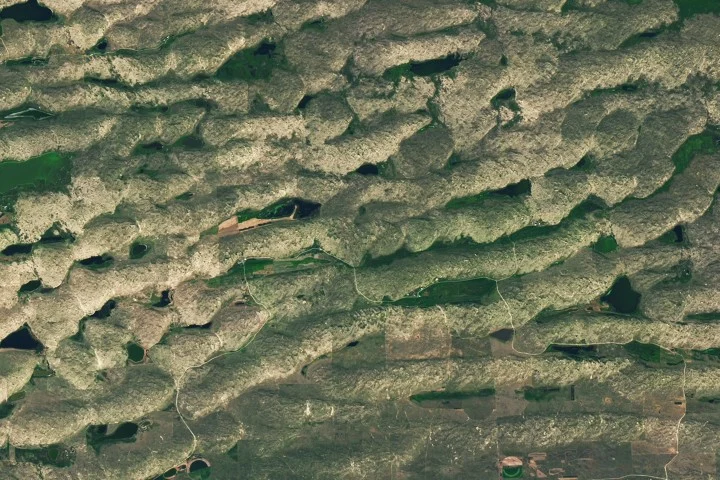
NASA’s Earth Observatory released high-resolution satellite imagery of the Nebraska Sandhills, detailing the formation, structure, and ecological features of this expansive dune field. The images capture the northern edge of the Sandhills, where some of the tallest dunes rise up to 400 feet (120 meters) and extend for several miles. These dunes were formed from sand eroded from the Rocky Mountains and transported by rivers and wind over thousands of years.
Key Facts
- The Nebraska Sandhills cover about 20,000 square miles (52,000 square kilometers), approximately one-quarter of the state.
- Some dunes reach heights of 400 feet (120 meters) and extend several miles in length.
- Sand originated primarily from Rocky Mountain erosion during the Pleistocene epoch.
- The dune slopes vary, with gentler northern slopes shaped by dominant northerly winds and steeper southern slopes.
- The grasslands covering the dunes serve as substantial rangeland, accounting for half of Nebraska’s nearly 23 million acres dedicated to pasture.
- Crescent Lake National Wildlife Refuge is located on the southwestern edge of the Sandhills, providing protected wetlands and habitats.
- The region’s wetlands recharge groundwater by absorbing precipitation instead of allowing surface runoff.
Why It Matters
The Nebraska Sandhills represent a critical ecological zone combining geological history and contemporary environmental importance. They support vast grasslands used for sustainable cattle grazing, mimic historic bison grazing patterns, and maintain wetlands vital for migratory birds and rare species. The dune system also plays a significant role in groundwater recharge for the surrounding Great Plains, underpinning regional water availability.
Background
The Sandhills formed as Pleistocene rivers transported eroded sandstone sediments from the Rocky Mountains across the Great Plains. Strong winds subsequently sculpted the sand into dunes around 3,500 years ago, when vegetation stabilized the formations. The area has been used extensively for ranching since the early 20th century, especially following the Kinkaid Act of 1904, which encouraged settlement and cattle grazing by allocating large land parcels.
Analysis
Scientists and land managers recognize the dunes’ unique geomorphology, shaped by directional wind patterns influencing dune asymmetry. Researchers from the University of Nebraska highlight the importance of the Sandhills’ sponge-like soil in sustaining groundwater levels. Ecologists emphasize that the rotational grazing patterns used by ranchers help conserve both the grasslands and local biodiversity.
Who Is Affected
Ranchers and livestock owners in Nebraska rely on the Sandhills’ extensive pasturelands for cattle grazing. Conservationists and wildlife agencies focus on protecting wetlands and native species like whooping cranes and the Topeka shiner. The local ecology and regional water resources also depend on the health of this dune system.
What Remains Unclear
This information was not confirmed in the reviewed sources.
What Comes Next
This information was not confirmed in the reviewed sources.
Sources
This article is based on reporting and publicly available information from the following source:
Read more Science & Technology stories on Goka World News.