
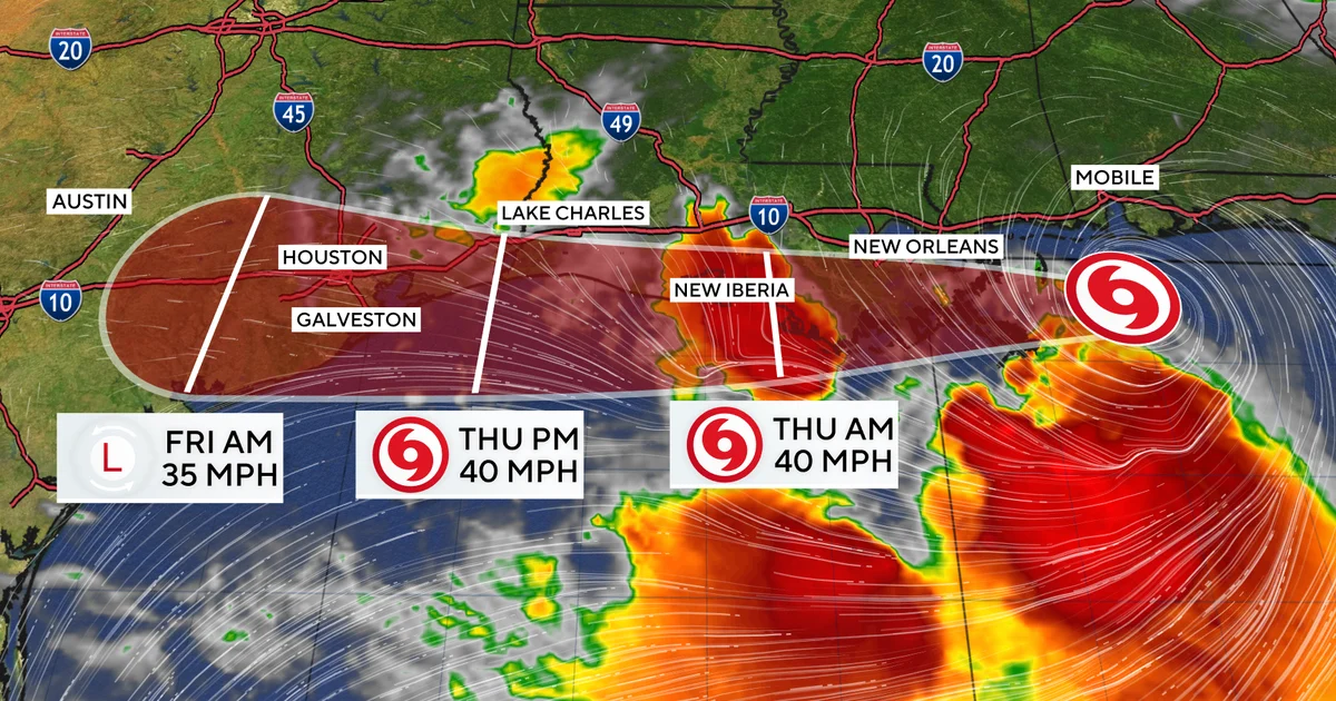
Tropical Storm Bertha, after making landfall in Louisiana on Wednesday, shifted westward and is now moving toward Texas, continuing to affect the northern Gulf Coast with heavy rain and tropical storm conditions. The National Hurricane Center has forecasted Bertha to reach the upper Texas coast later Thursday before dissipating inland.
What Happened
Bertha made landfall along the Louisiana coast on Wednesday, then moved offshore into the northern Gulf of Mexico early Thursday. The storm is traveling at roughly 13 mph westward toward the Texas coastline. According to the National Hurricane Center, Bertha is expected to maintain tropical storm strength with sustained winds near 45 mph as it approaches and moves along the Gulf Coast between Louisiana and Texas during the afternoon of July 23, 2026. It is projected to weaken and dissipate over Texas by late Thursday or Friday.
A tropical storm warning was in effect from the Terrebonne/Lafourche Parish line in Louisiana to Sargent, Texas, covering the areas expected to experience tropical storm conditions throughout the day. Meteorologists warned of 2 to 4 inches of rainfall, with localized amounts up to 6 inches likely, posing a risk of flash flooding especially in urban settings. Coastal areas were also warned about potential storm surge of up to 3 feet.
Key Facts
Bertha is the second named storm of the 2026 Atlantic hurricane season, following Tropical Storm Arthur, which made landfall on the Texas Gulf Coast in June. The National Hurricane Center in Miami confirmed Bertha’s sustained winds at 45 mph after a decrease from earlier intensities. Louisiana state climatologist Jay Grymes noted some potential flooding in parts of Louisiana but hoped for a brief impact window.
Tropical storm warnings covered a broad stretch along the northern Gulf Coast, with local emergency services monitoring potential flash floods and storm surges. Bertha’s westward movement kept it close to the Louisiana and upper Texas coasts before inland dissipation.
What This Means
For residents along the northern Gulf Coast from Louisiana to Texas, Tropical Storm Bertha presents risks mainly through heavy rainfall and flash flooding, particularly in urban areas where drainage can be poor. Although the storm is not expected to intensify beyond tropical storm strength, localized flooding can disrupt transportation, services, and daily life. Coastal communities must also remain vigilant against elevated water levels from storm surge, which can threaten low-lying areas and exacerbate flooding.
Bertha’s swift progression and moderate intensity highlight how even less severe tropical systems can create significant challenges for emergency responders and residents, emphasizing the need for preparedness during hurricane season. Those in affected areas should follow guidance from local authorities and be prepared for sudden weather changes, flooding alerts, and potential power outages.
With the Atlantic hurricane season underway and multiple storms possible, the impacts witnessed from Bertha in Louisiana and Texas serve as a reminder that Gulf Coast residents face repeated risks each season and must stay informed through official channels. Infrastructure resilience and emergency response protocols remain crucial to mitigating damage from these recurring weather events.
Background
Tropical Storm Bertha followed Tropical Storm Arthur, which made landfall along the Texas Gulf Coast in June 2026, marking the start of an active hurricane season in the region. Louisiana and Texas are frequently vulnerable states during hurricane season due to their extensive coastlines along the Gulf of Mexico. Forecasters monitor tropical storms closely as they often bring heavy rains, flooding, and strong winds that can impact communities regardless of whether they reach hurricane intensity.
What Comes Next
The National Hurricane Center will continue to track Bertha’s movement and issue updates as it progresses inland over Texas. Local officials in Louisiana and Texas remain on alert, providing information on weather conditions, flood advisories, and any necessary evacuations or emergency measures. State and local agencies are monitoring the storm’s impact, particularly regarding flooding and infrastructure status.
Sources
This article is based on reporting and publicly available information from the following source:
Read more US News stories on Goka World News.