
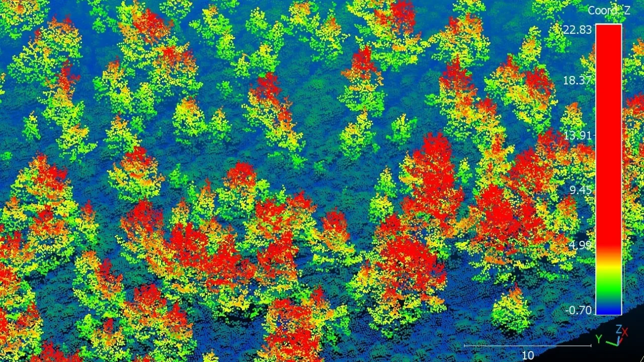
A University of Cambridge team has utilized advanced aerial LiDAR technology to produce detailed three-dimensional maps that track the recovery of native woodland across Scotland’s Cairngorms National Park. This study provides robust evidence that native trees are naturally regenerating over a large area, a significant step forward for the region’s native forest restoration.
What Happened
During 2026, researchers from the University of Cambridge collaborated with the Cairngorms Connect partnership to conduct an extensive aerial survey spanning 569 square kilometers of the Cairngorms National Park. Flying at an altitude of approximately 600 meters, they deployed airborne LiDAR—laser scanning technology—to collect precise spatial data on tree canopy height and distribution.
By processing the LiDAR data with a novel artificial intelligence-based analysis method, the team identified more than 6 million individual trees and measured their exact heights. They found that about 2.65 million of these trees—over 40%—were under five meters tall, indicating recent natural regeneration. These young trees predominantly clustered near forest edges but were also discovered up to half a kilometer away, demonstrating active woodland expansion.
Key Facts
The study confirmed over 5,235 hectares of land within the Cairngorms Connect area supported young woodland, defined as areas with more than 100 trees per hectare. This woodland has mostly established through natural seed dispersal, with planting restricted to small sites where seeds are scarce.
Data validation was conducted using ground-based spot checks and comprehensive field surveys by Cairngorms Connect and RSPB Scotland, confirming the LiDAR method’s reliability for large-scale forest monitoring. The research was published in the Journal of Applied Ecology in September 2026 (DOI: 10.1111/1365-2664.70561).
The study also identified habitat influences on regeneration rates, with tree establishment being less frequent in boggy areas compared to drier heathlands.
What This Means
This research demonstrates a scalable and highly precise method for monitoring natural woodland regeneration at landscape levels, which can significantly reduce the need for labor-intensive ground surveys. By accurately mapping millions of trees and tracking young forest growth, land managers and conservationists now have a powerful tool to measure restoration success and refine deer management practices that affect seedling survival.
Moreover, the findings support Scotland’s strategic goal of expanding native woodlands to enhance carbon sequestration and biodiversity. The natural regeneration of over 5,000 hectares suggests restoration efforts, especially those aimed at controlling deer populations, are proving effective without extensive planting efforts.
For local communities, this woodland recovery could improve ecosystem services, including habitat provision for species such as capercaillie and red squirrels, while also mitigating climate change impacts through carbon capture. The ability to monitor fire damage alongside regeneration provides a comprehensive approach to managing dynamic natural landscapes under shifting climate conditions.
Background
Scotland’s native coniferous forests have declined dramatically over centuries due to land clearance for agriculture and hunting. Today, only about 4% of the original Caledonian forest remains. The Cairngorms Connect partnership, established over ten years ago by RSPB Scotland, Forestry and Land Scotland, NatureScot, and WildLand Ltd., aims to double forest cover in the region through landscape-scale restoration, relying heavily on natural regeneration supported by improved deer management.
Previous progress tracking had depended largely on ground surveys, which are time-consuming and limited in scope. This study showcases the potential for airborne LiDAR technology to transform ecological monitoring.
What Comes Next
The research team hopes to apply this mapping approach routinely across Scotland and potentially in other UK regions to monitor woodland restoration efforts. As funding and interest in native woodland expansion increase, this technology could help guide landowner decisions and policy development for sustainable forest management.
Additionally, ongoing studies will test the method’s applicability for assessing fire impacts and other environmental changes, providing a dynamic monitoring framework for rapidly evolving landscapes.
Sources
This article is based on reporting and publicly available information from the following sources:
Read more Science Discoveries stories on Goka World News.