Intense rainfall from Tropical Cyclone Maila in April 2026 triggered landslides in the mountainous Gazelle district of East New Britain, Papua New Guinea, leading to multiple deaths. The cyclone’s slow movement allowed heavy rainbands to persist over the region, saturating steep slopes and causing slope failures.
Landslide Impact and Satellite Observations
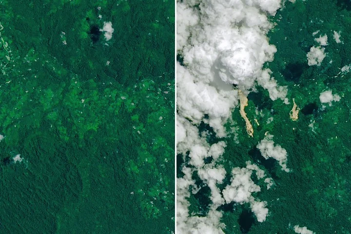
According to local news sources, the landslides around April 9 claimed several lives as earth and debris descended through the Baining Mountains area. The U.S. Geological Survey’s Landsat 9 satellite captured images on April 20, 2026, revealing fresh scars of exposed soil crossing dense tropical forests and extending toward nearby river valleys. These scars contrasted sharply with the surrounding green vegetation, underscoring the extent of landscape disruption.
Comparative imagery from September 24, 2025—prior to the event—shows the dense forest cover without visible signs of landslide damage, confirming the recent nature of the terrain failure.
Tropical Cyclone Maila’s Characteristics
Maila was an unusually intense tropical cyclone near the equator, a region where cyclones are rare due to weak Coriolis forces. The storm reached Category 4 on Australia’s cyclone scale (equivalent to Category 3 on the Saffir-Simpson hurricane scale used in the U.S.) and remained near Papua New Guinea longer than typical storms, allowing continuous heavy rainfall over East New Britain. NASA’s Global Precipitation Measurement (GPM) mission estimated that several hundred millimeters of rain fell in less than a week.
This prolonged rainfall contributed directly to ground saturation and slope instability, particularly in the rugged terrain of the Baining Mountains.
Scientific Monitoring and Landslide Risk
NASA’s Landslide Hazard Assessment for Situational Awareness (LHASA) model, which integrates rainfall data with topographic and land cover information, identified elevated landslide risk in East New Britain during Maila’s peak rainfall. This model’s warnings corresponded with the observed landslide occurrences.
Why it matters
These events highlight the increasing risks of severe weather and landslides in regions near the equator, where tropical cyclones are infrequent but can be intensified by warm ocean conditions. Understanding how intense, slow-moving storms affect vulnerable terrains is critical for disaster preparedness and early warning systems in Papua New Guinea and similar environments.
Background
Papua New Guinea’s proximity to the equator typically limits tropical cyclone formation due to weak Coriolis effects, which influence storm rotation. However, increasing sea surface temperatures and favorable atmospheric conditions occasionally produce powerful cyclones like Maila. The country’s mountainous topography, combined with heavy tropical rainfall, makes it susceptible to landslides, a leading cause of natural disaster fatalities in the region.
Sources
This article is based on reporting and publicly available information from the following source:
Read more World News stories on Goka World News.