About 15,000 years ago, a massive glacial lake called Lake Agassiz covered much of what is now southeastern Manitoba and surrounding regions. This lake, larger than all the Great Lakes combined, deposited thick layers of nutrient-rich silt and clay across the area, resulting in some of Canada’s most fertile farmland that remains extensively cultivated today.
Legacy of Lake Agassiz on the Landscape
Lake Agassiz formed as the Laurentide Ice Sheet retreated, blocking river drainage into Hudson Bay and creating an immense body of water spanning present-day Manitoba, Ontario, Saskatchewan, North Dakota, and Minnesota. Measuring approximately 1,100 kilometers long and 300 kilometers wide, the lake began draining around 12,000 years ago. Its ancient lakebed left a nearly flat terrain rich in fine sediments ideal for agriculture.
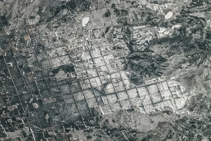
A photograph taken from the International Space Station in April 2026 shows farmland along the southern shore of Lake Winnipeg, an area once submerged beneath Lake Agassiz’s waters. The image reveals a geometric pattern of fields outlined by roads and drainage channels shaped by the Dominion Land Survey’s systematic 19th-century division of land.
19th-Century Land Survey Shapes Farming Today
Following Canada’s acquisition of Rupert’s Land from the Hudson’s Bay Company in 1869, the Dominion Land Survey divided much of western Canada into one-square-mile sections, imposing a grid that still influences the layout of fields, roads, shelterbelts, and drainage infrastructure on former lakebed farmland. The consistent grid pattern supports the cultivation of crops such as wheat, barley, oats, and canola throughout the region.
The April 19, 2026, astronaut photograph captured a snow- and ice-covered landscape, with bright white areas highlighting snow-covered farmland and frozen ponds, while darker regions indicate forests, wetlands, or exposed ground.
Recreation and Ecology Around Gull Lake
Located near the agricultural zone, Gull Lake features cottages and lake houses and is a popular destination for boating, fishing, and other water activities. The lake supports fish species including northern pike, walleye, and yellow perch, adding recreational and ecological value to the region.
Why it matters
Understanding the formation and sediment legacy of Lake Agassiz highlights the geological processes that created some of Canada’s richest agricultural lands, which continue to support regional food production. The enduring Dominion Land Survey grid illustrates how historical land-use planning still shapes farming practices and infrastructure layout in western Canada.
Background
Lake Agassiz was a major freshwater glacial lake formed during the last Ice Age, influencing hydrology and soil distribution across central North America. Its drainage significantly reshaped the landscape approximately 12,000 years ago, setting conditions for the biodiversity and human settlement patterns that followed. The Dominion Land Survey, established in the late 19th century, systematized land division in western Canada to facilitate agriculture and settlement after Canadian Confederation.
Sources
This article is based on reporting and publicly available information from the following source:
Read more Science Discoveries stories on Goka World News.