NASA’s Landsat 9 satellite performs a monthly calibration by imaging the full Moon, using the stable lunar surface as a reference to maintain the accuracy and consistency of its Earth observation data.
What happened
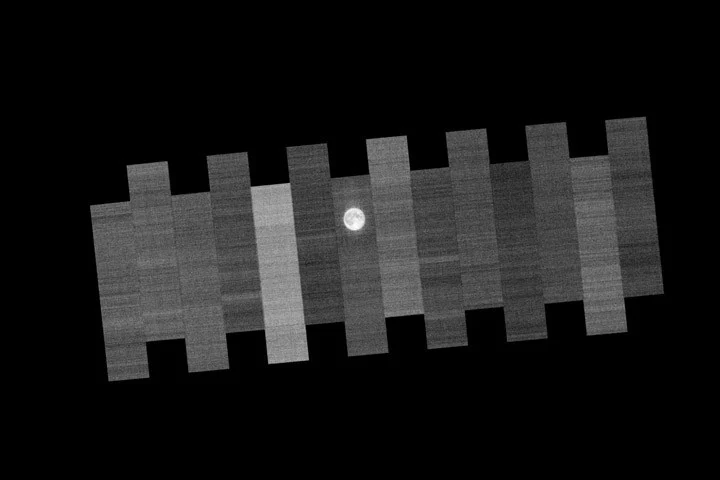
Once every month during the full Moon, Landsat 9 shifts its focus from Earth to the Moon to capture detailed images of the lunar surface. Over two orbits, the satellite images the Moon 15 times, with each of the 14 detector modules on its Operational Land Imager (OLI) instrument scanning the surface. This routine allows engineers to detect and correct any sensor drift or changes in the instruments, ensuring that the data collected remains consistent over time.
The Moon offers a uniquely stable reference body for calibration because it lacks an atmosphere and weather, and its surface changes minimally. This stability provides a predictable reflection of sunlight, unlike Earth’s dynamic environment with seasonal and weather-driven variations.
In addition to the lunar calibration, Landsat 9 also uses uniform terrestrial sites such as the White Sands desert in New Mexico and collects ground measurements for cross-verification. These comprehensive methods allow Landsat images to provide scientifically reliable information for tracking changes in agriculture, habitats, forests, and other land surface features.
Why it matters
Landsat 9 contributes to the longest continuous record of Earth’s land surface dating back to 1972, vital for monitoring environmental changes over time. Monthly lunar calibration is critical to maintain this data’s integrity, enabling accurate comparisons between new and historic images. Reliable satellite imagery supports scientific research, policy decisions, natural resource management, and climate studies worldwide.
Calibration practices like this uphold NASA’s reputation as a global standard for Earth science data quality, ensuring that satellite imagery remains trustworthy throughout the mission’s lifetime.
Background
The Landsat program, a joint effort by NASA and the U.S. Geological Survey (USGS), has been observing Earth’s surface for over five decades. Landsat satellites collect data used to analyze crop health, deforestation, glacial retreat, urban growth, and more.
Before and after launch, Landsat sensors undergo rigorous calibration to detect and correct any shifts in instrument behavior. Using the Moon as a stable reference point dates back to earlier Landsat missions and continues to be an essential part of calibration and validation efforts for ensuring data continuity and accuracy.
Sources
This article is based on reporting and publicly available information from the following source:
Read more Space & NASA stories on Goka World News.