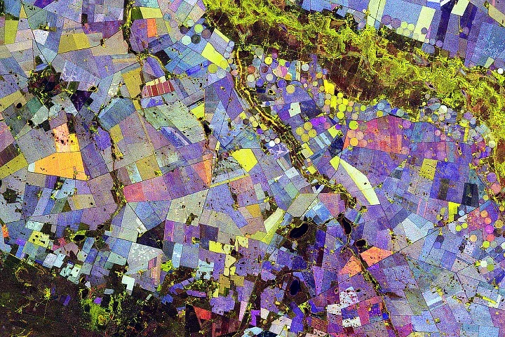
NASA’s NISAR satellite captured radar data over South Africa’s Maize Triangle, providing detailed insights into crop types and seasonal changes during the 2025-2026 Southern Hemisphere growing season. The radar imagery shows how crops like maize and sunflower develop and change in a semi-arid agricultural landscape along the Vet River in the Free State province.
What happened
Between November 2025 and March 2026, the NISAR (NASA-ISRO Synthetic Aperture Radar) satellite made 10 passes over a farmland area approximately 110 kilometers north of Bloemfontein, South Africa. Using L-band radar, which detects vegetation structure rather than color, scientists created a false-color composite image displaying crop conditions and land cover throughout the growing season.
The composite assigns colors based on vegetation status: green indicates vegetated areas, red signals unvegetated surfaces, and blue reflects the rate of vegetation change. For example, stable forests appear light blue, while crops such as maize and wheat that grow and change rapidly show darker blue shades. Fields exhibiting rapid growth followed by early harvesting, like sunflowers, appear orange in the imagery.
By analyzing co- and cross-polarized radar signals over multiple dates, researchers generated a data-rich map revealing crop development patterns, irrigation effects, and land use changes. This technique offers a repeatable and scalable method to monitor large agricultural regions and assess how crops respond to environmental conditions.
Why it matters
The NISAR radar data provides a new way to observe agricultural productivity and land use dynamics in detail over time without reliance on visual spectra, which can be obscured by clouds or weather. This capability enhances understanding of crop growth cycles and water use management in critical farming regions like South Africa’s Maize Triangle. Tracking such data annually will help scientists and farmers assess climate impacts and optimize agricultural practices.
Background
The Maize Triangle in South Africa is an important agricultural zone enabled by irrigation along the Vet River amid an otherwise semi-arid environment. NISAR, a joint NASA and Indian Space Research Organisation mission launched to capture global radar imagery, collects data that penetrate vegetation canopies and provide structural information about crops. The satellite’s repeated passes over farmland enable analysis of seasonal changes that are not easily captured by traditional optical satellite systems.
NISAR’s ability to differentiate crop types and growth stages supports efforts in land-use monitoring, climate adaptation planning, and resource management worldwide.
Sources
This article is based on reporting and publicly available information from the following source:
Read more Space & NASA stories on Goka World News.