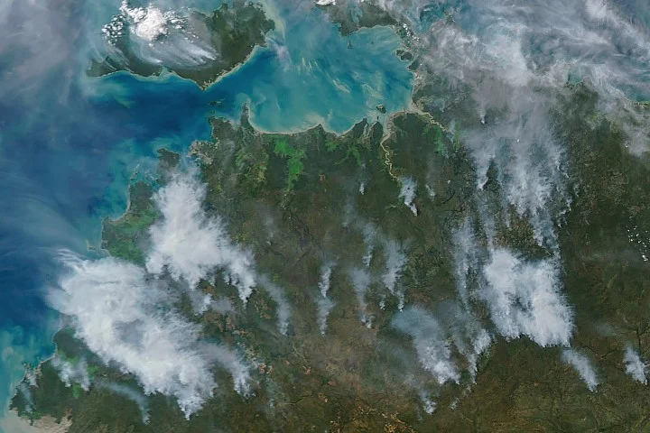
NASA satellites have provided clear imagery showing prescribed burns in Australia’s Northern Territory, where controlled fires are intentionally lit early in the dry season to minimize the risk and severity of larger wildfires later.
What Happened
In May and June of most years, NASA’s Aqua satellite and other Earth-observing instruments detect numerous fire-related thermal anomalies and smoke plumes over Northern Australia’s Top End and Arnhem Land regions. While some fires appear large and intense in afternoon satellite images, many are smaller, controlled burns ignited purposefully by land managers as part of fire management programs.
Key Facts
- Prescribed burns typically occur in the mornings, gradually producing visible smoke by afternoon.
- These fires consume grasses, underbrush, and scattered trees in savanna ecosystems adapted to periodic fire.
- Programs such as the West Arnhem Land Fire Abatement (WALFA) and Arnhem Land Fire Abatement integrate Indigenous fire practices with modern technology.
- The dry season in Northern Australia generally spans from May through September.
- Satellite analyses suggest these burns shift fire activity to earlier in the dry season, reducing more severe fires and emissions later on.
Why It Matters
Prescribed burning reduces fuel loads in fire-prone ecosystems, mitigating the scale and intensity of destructive wildfires that can harm biodiversity, release large amounts of greenhouse gases, and threaten communities. NASA’s satellite monitoring provides crucial evidence on the effectiveness and timing of these fire management efforts.
Background
Australia’s tropical savannas have evolved with fire, and Indigenous peoples have long used controlled burning for land management. Over recent decades, these traditional techniques have been combined with scientific methods and satellite technology to create large-scale, coordinated fire management programs aimed at environmental conservation and emissions reductions.
Analysis
Observations from NASA’s Aqua satellite and other Earth-monitoring systems reveal that prescribed burns occur systematically across vast areas in the early dry season. This correlates with reduced incidence of high-intensity wildfires later, supporting research published on the success of Arnhem Land’s fire abatement projects. The use of satellite data allows for ongoing evaluation of fire timing, extent, and smoke dispersion patterns.
Who Is Affected
These fire management activities impact Indigenous communities involved in traditional burning practices, local ecosystems, and the broader public by reducing wildfire risk and improving air quality. Additionally, global climate efforts benefit from lowered emissions resulting from reduced late-season fires.
Reactions / Official Statements
This information was not confirmed in the reviewed sources.
What Remains Unclear
The reviewed sources did not confirm specific quantitative data on the exact reductions in wildfire damage or emissions attributable to the prescribed burns for the 2026 season.
What Comes Next
Continuous satellite monitoring throughout the dry season will track fire activity, providing data to refine prescribed burn strategies. Research efforts are expected to further quantify the long-term ecological and climate benefits of these land management practices.
Sources
This article is based on reporting and publicly available information from the following source(s):
Read more Space & NASA stories on Goka World News.