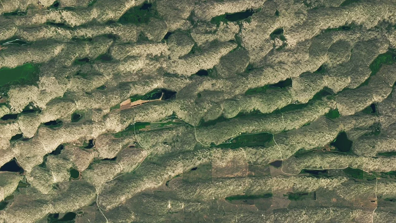
NASA’s Earth Observatory has released its June 2026 satellite image puzzler, inviting the public to identify the depicted location. Participants are encouraged to analyze the image closely and submit their guesses, along with any observations about the region’s geography or unique features.
What Happened
Each month, NASA Earth Observatory shares a satellite image that presents a geographic mystery for the public to solve. The June 2026 puzzler has been posted, featuring a satellite image that requires viewers to identify its location using visual clues. Interested individuals can submit their answers through NASA’s designated response form.
Key Facts
- The puzzler is a monthly feature by NASA Earth Observatory designed to engage the public with satellite imagery.
- Participants can guess the location, comment on its geological or historical significance, and suggest the specific satellite or instrument that captured the image.
- The challenge accepts answers submitted via an online form with “Puzzler Answer” as the chosen topic.
- NASA will reveal the correct location roughly one week after the challenge is posted.
- While there is no monetary prize, successful participants earn recognition and “puzzler bragging rights.”
Why It Matters
This interactive challenge promotes public awareness and appreciation of Earth observation technologies and satellite imagery. It encourages engagement with scientific data and nurtures interest in geography, geology, and remote sensing among a broad audience.
Background
NASA’s Earth Observatory has regularly provided the public with satellite-based challenges that combine education and entertainment. The puzzler series draws on data from Earth observation satellites equipped with advanced instruments capturing multispectral images of the planet.
Analysis
By inviting users to identify locations and details in satellite images, NASA fosters an active community of enthusiasts familiar with satellite instrumentation and Earth sciences. This contributes to informal science education and builds connections between space technology and everyday life on Earth.
Who Is Affected
The challenge targets Earth science enthusiasts, educators, students, and the general public interested in satellite imagery and geography. It provides an accessible way for people worldwide to engage with NASA’s satellite data.
Reactions / Official Statements
NASA encourages participants to share their observations and guesses, acknowledging the value of thoughtful contributions. The agency plans to publish the solution and highlight notable responses in a follow-up post on their Earth Observatory website.
What Remains Unclear
The exact geographic location depicted in the June 2026 satellite image will remain undisclosed until NASA releases the official answer. Details about the specific satellite, sensor, and spectral bands used were not confirmed in the reviewed sources.
What Comes Next
About a week after the puzzler’s release, NASA will disclose the correct image location and provide an accompanying explanatory story. The challenge will continue with future monthly images, maintaining public engagement with Earth observation science.
Sources
This article is based on reporting and publicly available information from the following source:
Read more Space & NASA stories on Goka World News.