
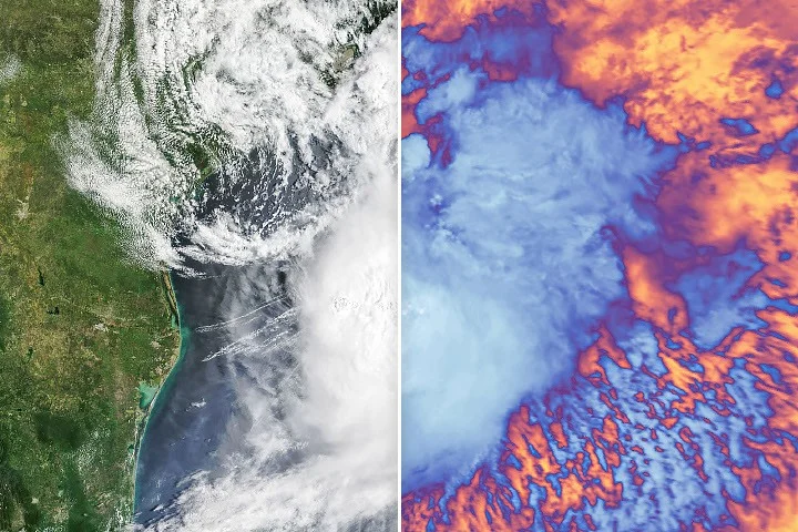
Tropical Storm Arthur, the inaugural named storm of the 2026 Atlantic hurricane season, brought intense wind and heavy rainfall to the U.S. Gulf Coast in mid-June, as captured by NASA’s Terra satellite. The storm did not reach hurricane strength but still posed significant flash flooding risks along the coastline.
What Happened
On June 17, 2026, NASA’s Terra satellite acquired natural-color and infrared images of Tropical Storm Arthur at 10:30 a.m. Central Time (15:30 UTC). At that time, the National Hurricane Center (NHC) had just recently classified Arthur as a tropical storm. The storm tracked northeastward along the Gulf Coast, producing sustained winds of 40 miles per hour (65 km/h) and gusts reaching 48 mph, as recorded in Galveston, Texas. Tropical-storm-force winds extended 175 miles (280 kilometers) from the storm’s center. Alongside strong winds, Arthur generated heavy rainfall prompting flash flood warnings.
Key Facts
The Terra satellite’s images highlighted cooler cloud tops in infrared, valuable for distinguishing storm intensity. Precipitation data from NASA’s Integrated Multi-Satellite Retrievals for GPM (IMERG) indicated high rainfall rates over the Gulf waters and onshore. On June 18, the storm weakened yet continued to deliver abundant moisture, with rainfall rates reaching 3 inches (7.6 cm) per hour in southeastern Louisiana. Forecasts projected total rainfall amounts exceeding 12 inches (30 cm) in many areas, with some locations expected to receive nearly 20 inches (51 cm).
What This Means
Although Tropical Storm Arthur did not escalate into a hurricane, its impacts underscore the significant risks that even tropical storms pose to coastal and inland regions. Heavy rainfall rates and expanded tropical-storm-force wind fields can disrupt communities through flooding and wind damage, challenging emergency response efforts. NASA’s satellite observations provide critical real-time insight into storm structure and progression, improving forecast accuracy and public safety warnings. Such data is essential for meteorologists to anticipate storm impacts on vulnerable Gulf Coast states, aiding timely preparations and disaster mitigation strategies.
Background
NASA’s Terra satellite, equipped with the MODIS instrument, routinely monitors Earth’s atmospheric and surface conditions. Terra’s infrared and visible imagery are vital for hurricane and tropical storm analysis, enabling the National Hurricane Center to assess storm intensity and rainfall distribution. The use of precipitation data from NASA’s Global Precipitation Measurement (GPM) mission further strengthens rainfall estimates essential for issuing warnings.
What Comes Next
The storm’s remnants continued to affect the central Gulf Coast states following June 18, with agencies monitoring rainfall totals and flash flooding risks. Ongoing satellite observations remain crucial to tracking moisture movement and storm dissipation. Officials will continue updating forecasts and hazard outlooks as the storm system evolves.
Sources
This article is based on reporting and publicly available information from the following source:
Read more Space & NASA stories on Goka World News.