
NASA’s Curiosity rover remains actively engaged in its ascent of Mount Sharp on Mars by investigating distinct bands of exposed rock. The rover’s recent operations have focused on characterizing textural and tonal differences in the bedrock, using a suite of imaging and analytical instruments.
What Happened
During sols 4920 and 4921 (Martian days), Curiosity positioned itself within a dark-toned, rough-textured bedrock unit. Since the bedrock texture prevented brushing, the rover conducted analysis “as is” using the Alpha Particle X-Ray Spectrometer (APXS) and the Mars Hand Lens Imager (MAHLI) on targets named “Salto La Cascada” and “Puerto de Rosas.” Concurrently, the Chemistry and Camera complex (ChemCam) performed Laser Induced Breakdown Spectroscopy (LIBS) on the bedrock target “Kishuara” and the small layered float rock “La Rosita.” ChemCam’s Remote Micro-Imager (RMI) captured detailed views of the “Mishe Mokwa” butte and nearby dune fields exhibiting tonal differences.
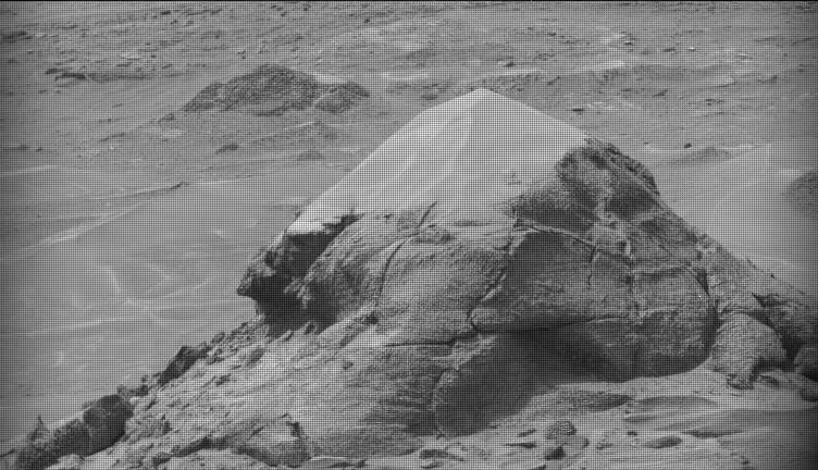
Mastcam mosaics documented several geological features including the “Valle Grande” channel, “Kimsa Chata” butte, surrounding troughs, and a uniquely shaped rock called “El Matir.” The rover then executed a drive closer to the upper boundary of this dark-toned rock band. Despite the continued inability to brush the rocks, APXS and MAHLI performed further analyses on dark-toned bedrock targets “Santa Gracia” and “Laguna San Rafael,” with ChemCam also acquiring LIBS spectra of these materials.
Additional Mastcam mosaics focused on layered rock formations and troughs, as well as “Miraflores,” a smaller butte displaying layered and ragged dark-toned rocks alongside stacked dust deposits. RMI mosaics of a bright unit on “Mishe Mokwa” were also collected, while Navcam conducted surveys for dust devils on both sols.
Communications between Earth and Mars experienced a delay on Sol 4923, resulting in a missed downlink that prevented planning the next drive or targeted science observations. To mitigate this, the team devised a contingency three-sol plan (sols 4924 to 4926) involving a 360-degree Mastcam mosaic, automatic AEGIS software targeting for ChemCam LIBS measurements, additional Navcam dust-devil surveys, APXS atmospheric measurements, and further environmental observations.
Upcoming plans include the first detailed examination of the next light-toned, smooth-textured rock band, alongside a new drive to continue surveying the stratigraphic bands on Mount Sharp.
Key Facts
Curiosity’s recent operations span sols 4920 to 4926 during its ongoing mission to study Mount Sharp’s stratigraphy. The rover utilized APXS, MAHLI, ChemCam LIBS, and its RMI camera to analyze dark-toned bedrock units and layered float rocks. Mastcam mosaics captured multi-angle views of geological features including channels, buttes, and sedimentary layers.
Communication delays on Sol 4923 exemplified one of the operational challenges of Mars surface missions, prompting the execution of an alternative plan featuring autonomous targeting and comprehensive imaging. Environmental monitoring continued with Navcam dust-devil surveys and atmospheric measurements.
What This Means
Curiosity’s detailed investigation of compositional and textural variations in rock bands on Mount Sharp advances understanding of Mars’ sedimentary history and past environmental conditions. By studying distinct rock units at close range, the mission provides context for the planet’s geologic evolution and potential habitability in ancient times.
The ability to adapt mission planning in response to communication delays highlights the robustness of current Mars operations and the importance of autonomous scientific targeting software like AEGIS. Moreover, observing surface features such as dust devils informs knowledge about current Martian atmospheric dynamics, which is essential for future missions.
As Curiosity progresses toward lighter-toned rock layers, it moves closer to assessing diverse geochemical environments, which could reveal changes in water activity or sediment deposition processes. This ongoing work continues to shape a comprehensive picture of Mars’ geological past, directly informing the broader field of planetary science.
Background
Curiosity landed in Gale Crater in 2012 and has been ascending Mount Sharp, a central peak composed of layered sedimentary rocks that preserve a record of Mars’ climatic and environmental history. The rover’s suite of instruments enables detailed in situ analysis of rock chemistry, mineralogy, and morphology, essential for reconstructing the planet’s geologic past.
What Comes Next
Following the recent survey of the dark-toned band, mission planners will analyze new downlinked data to initiate the first investigation of the next band characterized by smoother, lighter-toned bedrock. Continuing drives and surveys are scheduled to extend Curiosity’s stratigraphic sampling and surface characterization as the rover climbs the mountain.
Sources
This article is based on reporting and publicly available information from the following source:
Read more Space & NASA stories on Goka World News.