
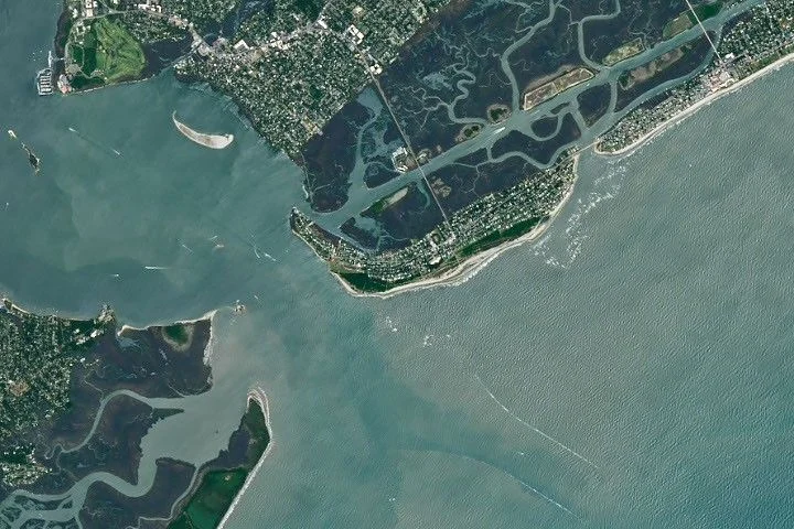
NASA’s Landsat 8 satellite has provided detailed images of Sullivan’s Island, South Carolina, bringing renewed focus to the site of a decisive Revolutionary War battle fought on June 28, 1776. This barrier island near Charleston served as the setting where colonial troops successfully repelled a British assault, helping to prevent the British occupation of Charleston and boosting American morale during the nation’s fight for independence.
What Happened
On June 28, 1776, British forces launched a concerted attack on Sullivan’s Island, targeting Fort Sullivan constructed mostly from palmetto logs at the island’s southern tip. The British had planned a shallow-water crossing of Breach Inlet, but deeper-than-expected waters forced them to use flatboats, which limited troop numbers during the amphibious assault. Alongside the naval bombardment by British warships, roughly 800 colonial defenders, including Catawba warriors, manned earthen defenses and artillery positions. The fort’s walls, filled with sand and backed by palmetto timber, absorbed much of the incoming cannon fire, sustaining few casualties among the defenders. The colonial forces focused on disabling the ship of British commander Sir Peter Parker, inflicting heavy damage and casualties. After a grueling ten-hour battle, the British retreated, marking a rare and important victory for largely untested colonial forces.
Key Facts
The recent images from NASA’s Landsat 8, captured on June 3, 2026, show the island’s current landscape of sandy beaches and salt marshes, broadly similar to the terrain faced by combatants 250 years ago, albeit with modern traces of roads and development. Fort Sullivan—later renamed Fort Moultrie in honor of the fort’s commanding officer—was originally built with 16-foot-wide, sand-packed palmetto log walls holding 31 cannons. The fort’s marshy core absorbed many incoming cannonballs, which helped neutralize the British bombardment. Around 3,000 British troops were positioned on nearby Long Island (current Isle of Palms), readying for a crossing that was thwarted by unfavorable tidal conditions and geography. The battle lasted from morning until evening, ending with a British withdrawal.
What This Means
This satellite-based imagery serves not only to preserve the visual memory of a critical site in American history but also highlights how natural geography played a vital role in shaping military outcomes. The durability of palmetto wood and the island’s shallow, marshy waters were decisive factors that colonial forces leveraged effectively. Understanding such environmental influences deepens appreciation for the strategic interplay between human engineering and landscape in early American conflicts. This historical perspective is enriched by modern remote sensing, which preserves the geography that shaped a pivotal moment in the nation’s founding struggle. For the public, the images present a tangible link between past and present, underscoring how subtle natural features can influence major historical events. The enduring symbolism of the palmetto tree on South Carolina’s flag reflects this meaningful connection.
Background
The Battle of Sullivan’s Island occurred the same day the Committee of Five, including Thomas Jefferson, presented the initial draft of the Declaration of Independence in Philadelphia. The colonial victory helped secure Charleston from British capture early in the Revolutionary War. Fort Sullivan’s construction involved enslaved labor and was designed with innovative sand-packed palmetto log walls to absorb cannon fire, an approach validated by the battle’s outcome. The victory inspired the renaming of the fort to Fort Moultrie and adopted the palmetto tree as a symbol of resilience and defense, now emblematic throughout South Carolina.
What Comes Next
NASA’s continued use of Landsat satellites provides ongoing opportunities to monitor and document historically significant landscapes worldwide. Observations of Sullivan’s Island not only aid environmental and developmental studies but contribute to preserving cultural heritage sites by supplying high-resolution images available for research and public engagement. Future analyses may provide insights into subtle changes in topography and vegetation, helping maintain awareness of this landmark in American history.
Sources
This article is based on reporting and publicly available information from the following sources:
Read more Space & NASA stories on Goka World News.