
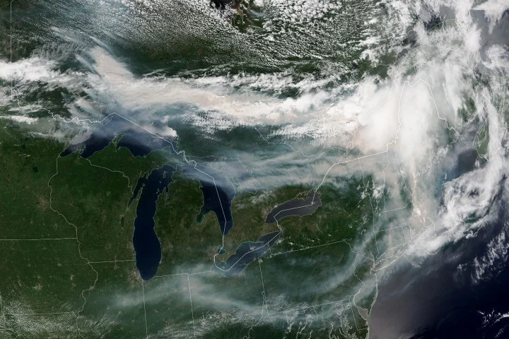
Satellite observations from NASA and NOAA have revealed large plumes of smoke originating from wildfires in Ontario, Canada, spreading southeastward across Quebec and into parts of the U.S. Midwest and Northeast. The images captured in mid-July 2026 provide a detailed look at the regional scale of wildfire smoke dispersal and its environmental impact.
What Happened
On July 14, 2026, the NOAA-21 satellite captured imagery showing dense smoke billowing from multiple active wildfires in Ontario. By mid-July, nearly 850 fires were burning across Canada, with over 180 of these in Ontario alone. The smoke was driven largely by winds moving it southeast over southern Ontario and adjacent regions, including Quebec and the U.S. Midwest and Northeast. These conditions followed a period of warm, dry weather that intensified fire activity after a slow start to the season.
Key Facts
- Wildfires burned approximately 1.9 million hectares (4.7 million acres) across Canada by mid-July 2026.
- The Canadian Interagency Forest Fire Centre reported around 850 active fires nationwide, with more than 180 in Ontario.
- Smoke from the fires affected air quality, particularly at ground level, with Toronto reaching unhealthy air quality levels as per AirNow.
- The significant growth of eight major fires in Northwestern Ontario on July 13 and 14 led to evacuation orders for affected communities.
- The satellite imagery used VIIRS data from NASA’s Earth Observing System Data and Information System (EOSDIS) LANCE and the Joint Polar Satellite System (JPSS).
What This Means
The satellite tracking of wildfire smoke provides critical real-time data on the extent and movement of smoke plumes, which plays a vital role in public health advisories and emergency responses. For communities impacted by smoke, like those in southern Ontario, this information helps authorities issue timely evacuation orders and air quality warnings. Beyond local effects, the wide dispersal of smoke into the U.S. highlights the transboundary nature of wildfire impacts and the importance of international cooperation in monitoring and managing air quality.
Moreover, the imagery underscores how changing climate and weather patterns contribute to wildfire risk and severity, affecting millions of people downwind. With heat waves compounding health risks, satellite data enables more accurate forecasting of smoke behavior, which is essential for protecting vulnerable populations.
Background
Canada’s 2026 wildfire season started slowly but intensified by late June due to dry and warm conditions. The seasonal outlook from North American fire experts indicates shifts in fire risks throughout July to September, influenced by evolving weather. The fires of 2026, while significant, remain below the extremes recorded in 2023 and 2025. This pattern of variability demonstrates the challenges of wildfire management in changing environmental conditions.
What Comes Next
Fire management agencies in Canada and the U.S. continue to monitor active wildfires and forecast smoke dispersion using satellite data. Officials have warned residents of southern Ontario and downwind areas to prepare for ongoing air quality fluctuations. Scientists and emergency responders await further satellite observations to assess fire growth and potential new evacuations. Seasonal forecasts will guide resource allocation as the fire season progresses through late summer.
Sources
This article is based on reporting and publicly available information from the following sources:
Read more Space & NASA stories on Goka World News.