
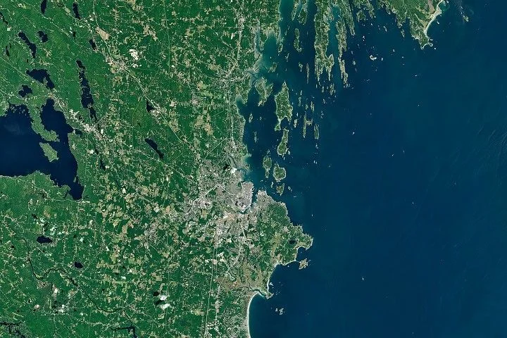
The contrasting shorelines of Maine—sandy beaches in the south and jagged, rocky coasts to the east—have been clarified through NASA satellite data and geological research. This difference, seen vividly in Landsat imagery, is linked to variations in underlying bedrock and sediment deposition shaped by glacial activity.
What Happened
NASA’s Earth Observatory satellite imagery, coupled with analysis from the Maine Geological Survey, highlights the distinct coastal morphology around Portland, Maine. Southern Maine features expansive sandy beaches and salt marshes, particularly at Saco Bay, while the Midcoast region east of Portland is characterized by a rugged, rocky shoreline with numerous narrow peninsulas and islands. These contrasting features originate from differing bedrock types and sediment transport processes that date back to the last glacial maximum.
Key Facts
- The southern Maine coast boasts broad sand deposits sourced mainly from rivers such as the Saco River, carrying weathered sediment from the White Mountains.
- Saco Bay contains Maine’s longest contiguous beach and largest salt marsh.
- The Midcoast region’s shoreline features metamorphic bedrock formations, ridges, and valleys carved by glaciers.
- Glaciers scoured coastal valleys during the last ice age, with post-glacial sea level rise flooding these depressions to create indented shorelines and many islands, particularly around Casco Bay.
- The orientation of islands and peninsulas in Casco Bay is shaped by the folded metamorphic bedrock’s structural direction, influencing erosion patterns.
- NASA uses Landsat data to assist aquaculture efforts, aiding in mapping water temperatures and conditions relevant to oyster farming in the rocky inlets.
What This Means
Understanding the geological origins of Maine’s coast provides insight beyond academic interest by impacting the region’s economy and environmental management. The sandy beaches of southern Maine attract tourism, supporting local economies through recreation and hospitality. In contrast, the rocky, sheltered waters of the Midcoast foster thriving lobster fisheries and aquaculture, particularly oyster farming. These rocky coastlines, shaped by ancient metamorphic rock and glacial sculpting, create habitats conducive to commercially valuable marine species.
Moreover, NASA’s satellite observations are becoming practical tools for local industries. For oyster farmers, for instance, monitoring water temperature and quality via remote sensing guides site selection and helps predict growth rates. This application reflects a broader trend where space-based Earth observation technologies contribute to sustainable management of coastal resources, helping communities adapt to environmental change and economic demands.
Background
Indigenous Wabanaki creation myths offer cultural narratives for the jagged coasts of Downeast Maine and the Bay of Fundy, involving the mythical figure Glooscap shaping the landscape. Scientifically, geological explanations trace Maine’s coastline to bedrock composition and glacial history. Glaciers from the Laurentide Ice Sheet carved valleys and reworked sediment, and as they melted, rising sea levels flooded these terrains to produce present-day coastal forms. The Maine Geological Survey’s studies have documented these bedrock types and sediment deposits, confirming the division between sandy southern shores and rocky Midcoast geologies.
Analysis
Geologists Peter Slovinsky and Nicholas Whiteman from the Maine Geological Survey explain that the difference in coastline form is controlled by the type and structure of the bedrock. The more erosion-resistant granite dominates parts of southern Maine, while metamorphic rock with complex folded layers shapes the eastern shores. These structural features direct erosion preferentially along certain orientations, producing the distinctive patterns of islands and peninsulas, notably in Casco Bay.
What Comes Next
Researchers, including those at the University of Maine, continue to leverage NASA Landsat imagery and other satellite data to monitor coastal conditions and support aquaculture development. Future studies aim to refine models predicting oyster growth and assess environmental health at fine scales, enhancing sustainable coastal resource management in Maine.
Sources
This article is based on reporting and publicly available information from the following sources:
Read more Space & NASA stories on Goka World News.