
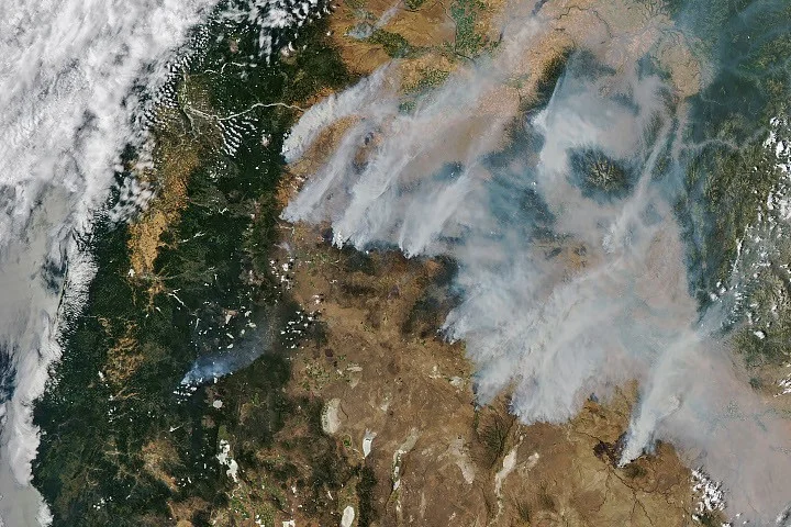
Lightning storms sparked dozens of wildfires across central and eastern Oregon in mid-July 2026, creating thick smoke blankets visible from space. NASA’s Aqua satellite captured images showing extensive smoke plumes drifting northeast as fires rapidly expanded in drought-stricken landscapes. These observations have played a vital role in monitoring fire progression and guiding emergency responses.
What Happened
On the evening of July 15, 2026, a series of dry thunderstorms formed over Oregon’s Cascade Range, unleashing thousands of lightning strikes across Oregon and Washington. These strikes ignited numerous wildfires that initially were small but grew quickly as gusty winds and prolonged summer heat fanned the flames. By July 26, NASA’s Aqua satellite, equipped with the Moderate Resolution Imaging Spectroradiometer (MODIS), captured a striking image of smoke rising from multiple active fires across Oregon.
Among the largest active fires reported were the Hay Creek Complex, Brewer, Big Grass, Akawa Butte, and Powder River fires, several of which had containment levels below five percent, as noted by the National Interagency Fire Center. The intensity of the fires forced state officials to issue air quality advisories for eastern Oregon and enforce evacuation orders in threatened communities. To bolster firefighting efforts, Oregon activated its Emergency Conflagration Act for particularly dangerous blazes such as the Shingle, Bench, Beachcomb, and Second Flat fires.
Key Facts
NASA’s satellite data confirmed that the fires had burned more than one million acres in Oregon by July 27, 2026. Across the United States, wildfires had scorched over four million acres during 2026’s season, surpassing the 10-year average of 3.4 million acres for this time of year. The Aqua satellite’s imagery utilized MODIS data obtained through NASA’s Earth Observing System Data and Information System (EOSDIS) and the Global Imagery Browse Services (GIBS) Worldview platform, providing near real-time fire detection and smoke monitoring.
Fire monitoring tools such as NASA’s Fire Information for Resource Management System (FIRMS) and Fire Event Explorer have been instrumental in tracking the rapid development and spread of the wildfires. Over 10,000 firefighters were mobilized statewide to combat the numerous fires concurrently burning under extreme drought conditions.
What This Means
The comprehensive monitoring from NASA satellites offers critical support to emergency management and firefighting agencies by enabling accurate, timely detection of fire outbreaks and smoke dispersion. This capability enhances situational awareness, allowing for more informed decisions on evacuations and resource deployment to protect communities and critical infrastructure.
The extent of these fires and their rapid growth underline the increasing challenges posed by extreme drought and climate-related weather patterns in the western United States. Satellite data helps quantify the scale and intensity of such fires, contributing to better forecasting models and long-term wildfire mitigation strategies. For residents, the growing smoke coverage poses significant health risks, emphasizing the importance of air quality monitoring enabled by these space-based assets.
Background
Oregon’s wildfires in July 2026 followed a trend of increasingly severe fire seasons in the western U.S., fueled by prolonged drought, higher temperatures, and dry lightning events. The National Interagency Fire Center and various state agencies rely on satellite data to track fire conditions and coordinate multi-agency responses. NASA’s Earth science missions have historically provided crucial insights through tools like MODIS, which regularly monitors global wildfire activity and environmental changes.
What Comes Next
Fire teams continue battling the active blazes with containment efforts concentrated on the largest complexes. NASA and partner agencies will keep providing updated satellite imagery and fire data to emergency responders and the public. Continued monitoring is critical as weather conditions, including winds and temperature, will determine fire behavior in the upcoming days and weeks.
Sources
This article is based on reporting and publicly available information from the following sources:
Read more Space & NASA stories on Goka World News.