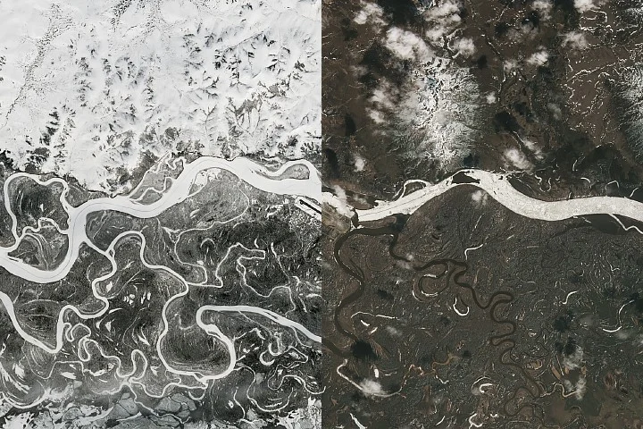
The spring thaw along Alaska’s Kuskokwim River has led to significant ice breakup and flooding concerns near the town of Aniak. A large ice jam formed upstream of Aniak by early May 2026, temporarily blocking river flow and causing water levels to rise. By May 7, the ice jam began moving downstream, though flood risks persisted as new jams formed closer to the community.
Satellite imagery from NASA’s Landsat 9 captured the conditions on April 21 and May 7, illustrating the transition from extensive river ice cover in late April to dynamic ice movement by early May. On April 16, river ice near Aniak was still thick and heavily snow-covered, supporting a 350-mile winter ice road that closed on April 10. By early May, the ice breakup front had nearly reached the town, causing a jam stretching approximately 21 miles upstream, with ice chunks several feet thick accumulating along riverbanks.
Flood watches were issued for Aniak beginning May 8 as waters overflowed low-lying areas and approached homes and businesses near the east side of the local airport runway. Floodwaters receded two days later, but the situation underscored the hazards posed by spring ice breakup.
Why it matters
Ice jams during spring thaw are a major flooding risk in interior and western Alaska, particularly when winter leaves behind thick snowpack and resilient river ice. A “dynamic breakup” occurs when melting snowwater meets intact river ice, causing water to back up rapidly and flood nearby areas. In 2026, this risk was heightened by below-average temperatures during winter and early spring, which delayed ice weakening. Arctic and Alaska river forecast centers monitor such conditions to provide timely alerts and mitigate damage to communities like Aniak.
Background
Spring breakup flooding is a common seasonal concern in Alaskan river regions. The Kuskokwim River typically experiences winter ice thick enough to support long ice roads connecting remote villages. When warming temperatures trigger rapid ice breakup, large floating ice sheets can become lodged, creating jams. These jams block river flow, causing upstream flooding and potential damage to infrastructure. Forecasting and observation using satellite data and local reports help to manage safety and emergency response efforts during these events.
Sources
This article is based on reporting and publicly available information from the following source:
Read more US News stories on Goka World News.