A strong EF-3 tornado struck southern Mississippi on May 6, 2026, carving an extensive path of destruction across five counties with wind speeds up to 137 miles per hour. The tornado traveled nearly 82 miles, making it one of the longest recorded in the state’s history, according to the National Weather Service (NWS).
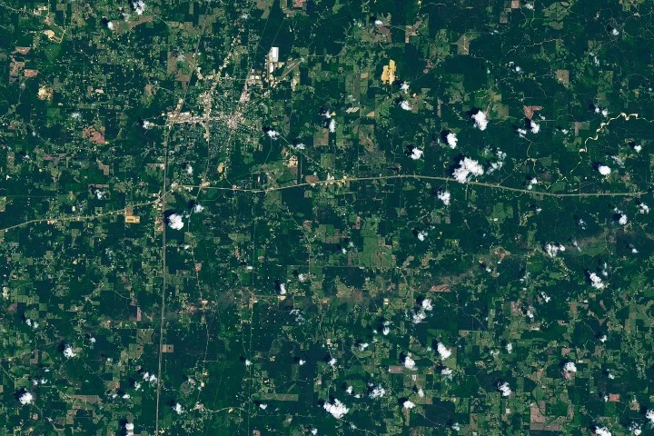
The tornado began near the St. Catherine Creek National Wildlife Refuge close to the Mississippi River, about 60 miles west-southwest of Brookhaven. It moved eastward, leaving a visible trail of damaged vegetation captured by NASA’s Landsat 8 satellite on May 12. The satellite imagery showed a brownish track where trees were snapped, uprooted, and stripped of bark and branches, particularly in Lincoln County where severe EF-3 damage was reported.
Damage Assessments and Impact
Post-storm surveys found extensive tree damage throughout the tornado’s path. Structural damage ranged from EF-2 to EF-3 levels, including the collapse of exterior walls on a home and severe destruction at a mobile home park, which was described as “devastated with debris” by NWS officials. Transmission towers were also bent or toppled in some locations.
The Mississippi Emergency Management Agency reported that over 400 homes and numerous businesses and farm buildings statewide were damaged, with most of the impact concentrated in Lincoln County. Seven tornadoes touched down in Mississippi on the evening of May 6, with this EF-3 tornado being the most significant. At least 17 people were reported injured overall according to preliminary reports from AccuWeather.
Why it matters
Mississippi and the broader southeastern United States are outside the traditional “Tornado Alley,” yet this region still experiences frequent tornado activity, especially in spring and late autumn. April and May typically see the highest monthly averages for tornadoes in Mississippi, with April averaging over seven and May just above three.
Recent meteorological research suggests a shift in tornado frequency away from the Great Plains and into parts of the Southeast. This underscores the need for increased awareness and preparedness in areas historically considered less vulnerable to significant tornado outbreaks.
Background
The Enhanced Fujita Scale (EF Scale) is used to rate tornado intensity based on damage caused. EF-3 tornadoes produce wind speeds between 136 and 165 miles per hour and cause severe damage. NASA’s Landsat satellite program, operated in partnership with the U.S. Geological Survey, provides detailed Earth imagery that can reveal storm impact patterns over large areas days after events.
Southern Mississippi’s exposure to tornadoes is linked to seasonal atmospheric patterns that favor supercell development in spring. The May 6 storm system generated multiple twisters, with the EF-3 tornado being the longest-lasting and most destructive. Continuous monitoring and damage assessments by agencies like the NWS and state emergency management help inform public safety efforts and resource allocation following such events.
Sources
This article is based on reporting and publicly available information from the following source:
Read more US News stories on Goka World News.