On May 27, 2026, an astronaut aboard the International Space Station captured a striking image of San Francisco, revealing the city’s blend of urban development, prominent bridges, and expansive green spaces during a moment of clearing weather.
What Happened
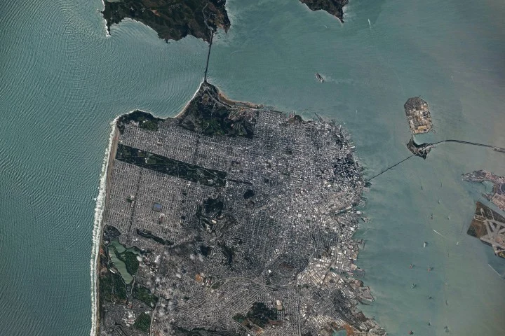
Following a period of scattered showers and thunderstorms in California’s Bay Area, a break in the clouds allowed for a clear view of San Francisco from space. An astronaut on Expedition 74 used a high-powered Nikon Z9 camera to photograph the city’s downtown, surrounding neighborhoods, and its iconic infrastructure from the vantage point of the ISS.
Key Facts
The photo prominently shows two of San Francisco’s signature bridges: the Golden Gate Bridge connecting the northern peninsula with Marin County, and the San Francisco-Oakland Bay Bridge spanning eastward across the bay. Golden Gate Park is visible as an over 1,000-acre green rectangle amid dense urban settings. The image also captures the patchwork of the city’s distinct street grids adapted to its hilly terrain, with Market Street serving as a dividing line between two grid patterns.
Along the northeastern waterfront, historic piers and wharves constructed mainly in the early 20th century are visible. The bay waters support a variety of maritime traffic including cargo ships, cruise vessels, and ferries. Waves break along Ocean Beach on the western shore, where hazardous beach conditions were reported due to strong winds and ocean swells at the time.
Why It Matters
This photograph offers a unique perspective on how urban growth, natural landscapes, and maritime activity coexist in a major metropolitan area. Images like this aid scientists, urban planners, and the public in understanding spatial relationships within dense cities, the extent of green spaces, and coastal environments vulnerable to environmental change.
Background
The International Space Station regularly supports the Earth Science and Remote Sensing Unit at NASA’s Johnson Space Center by enabling astronauts to photograph Earth’s features with advanced cameras. These images, freely available to the public, provide valuable insight into urban development and environmental conditions from a global vantage point.
Analysis
The clear aerial perspective highlights how San Francisco’s historic and modern urban planning incorporates natural elements like parks, water bodies, and coastal areas. The marked division of street grid patterns underscores the city’s complex expansion over varied terrain. Coastal maritime infrastructure reflects the area’s economic importance and longstanding maritime heritage.
Who Is Affected
The city’s residents, urban developers, environmental agencies, and maritime operators are directly influenced by San Francisco’s spatial layout and environmental conditions. Researchers and policymakers benefit from these satellite-based observations to monitor urban and coastal changes over time.
Reactions / Official Statements
This information was not confirmed in the reviewed sources.
What Remains Unclear
This information was not confirmed in the reviewed sources.
What Comes Next
Additional images from the ISS will continue to document urban and environmental dynamics globally. Continued observation of San Francisco’s urban and coastal evolution will support scientific research and public awareness of city planning and environmental challenges.
Sources
This article is based on reporting and publicly available information from the following source:
Read more Space & NASA stories on Goka World News.