NASA’s Tropospheric Emissions: Monitoring of Pollution (TEMPO) mission has provided unprecedented hourly observations of nitrogen dioxide (NO2) and ozone levels across the Northeast United States, offering new insights into the daily dynamics of air pollution along the densely populated New York–Washington corridor.
What Happened
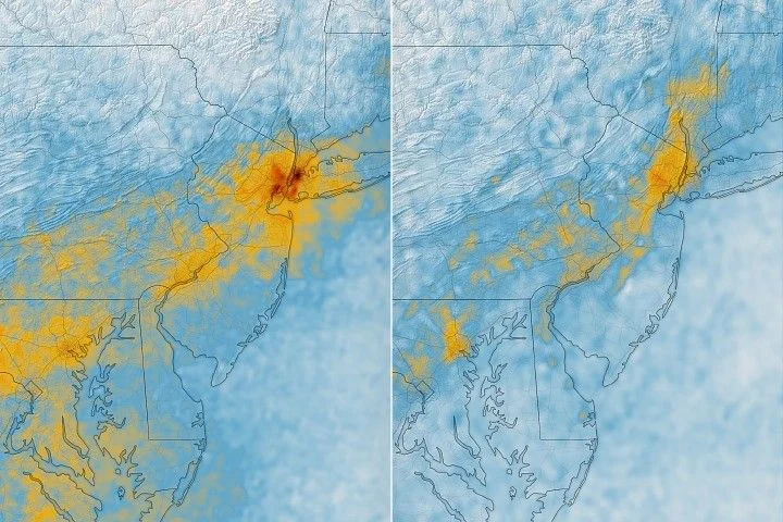
In May 2026, a mid-month heat wave triggered early ozone formation warnings issued by New York state health and environmental agencies. On May 17, a code orange health advisory was announced due to concerns about elevated ground-level ozone linked to respiratory and cardiovascular risks. Through geostationary orbit, TEMPO observed nitrogen dioxide concentrations during the morning rush hour and tracked their decline by the afternoon as ozone levels climbed, reflecting the chemical processes driving ozone formation.
Key Facts
- TEMPO operates from a geostationary orbit roughly 22,000 miles above Earth, providing hourly observations of air pollutants.
- The instrument detects nitrogen dioxide, emitted mainly from burning fuels such as vehicle exhaust, which contributes to ozone formation.
- Data showed high NO2 during morning commutes that decreased significantly by late afternoon, correlating with increased ozone due to sunlight-driven chemical reactions.
- Ground-based sensors corroborated TEMPO’s readings, confirming ozone reached unhealthy levels for sensitive groups on May 18.
- TEMPO also detected stratospheric ozone descending into the troposphere on May 19, indicating vertical ozone transport influences air quality.
- Earlier orbital sensors provided less frequent data; TEMPO’s hourly measurements represent a significant improvement.
Why It Matters
Real-time tracking of pollution dynamics helps improve air quality forecasts and health advisories affecting millions of people. Understanding the timing and distribution of nitrogen dioxide and ozone assists policymakers and public health officials in managing exposure risks and mitigating pollution sources.
Background
The New York–Washington corridor is home to over 35 million people and experiences recurrent ozone pollution episodes, especially during warm months. Ozone forms when nitrogen dioxide, volatile organic compounds, and sunlight interact. TEMPO, launched in 2023, is the first satellite instrument to monitor these pollutants hourly from geostationary orbit, enhancing spatial and temporal resolution beyond previous polar-orbiting satellites.
Analysis
Data from TEMPO reveal a clear daily cycle of nitrogen dioxide depletion and ozone increase, driven by photochemical reactions fueled by sunlight. This cycle’s detailed mapping provides insights into emission sources and atmospheric chemistry that were previously unattainable at such fine time scales. Additionally, detecting stratospheric ozone descending into the troposphere introduces complexity into understanding surface air quality and highlights the need for integrated observational approaches.
Who Is Affected
Residents along the New York–Washington corridor, particularly sensitive groups such as children, the elderly, and outdoor workers, are impacted by fluctuations in ozone and nitrogen dioxide levels. These pollutants can exacerbate respiratory and cardiovascular conditions and affect daily outdoor activities.
Reactions / Official Statements
NASA atmospheric scientist Hazem Mahmoud emphasized TEMPO’s value in filling data gaps between ground stations and improving air quality models and forecasts. Health advisories issued by New York authorities reflect growing reliance on such data for public safety decisions.
What Remains Unclear
This information was not confirmed in the reviewed sources.
What Comes Next
Researchers will continue refining TEMPO data processing and integrating observations with ground-based networks to enhance air quality forecasting models. Publicly accessible near-real-time data facilitate ongoing monitoring and may guide responses to pollution episodes, including those affected by natural phenomena such as sea breezes and stratospheric intrusions.
Sources
This article is based on reporting and publicly available information from the following source:
Read more Space & NASA stories on Goka World News.