
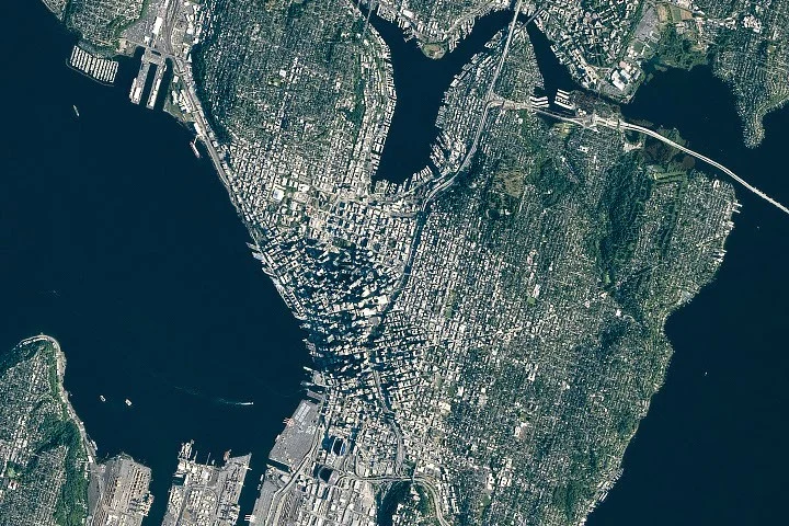
An astronaut on the International Space Station (ISS) captured a striking image of Seattle, Washington, on June 16, 2026, highlighting the city’s distinctive combination of glacial geology and modern urban development. The photo reveals Seattle’s lush greenery, shaped by ancient ice flows, alongside recent waterfront infrastructure projects completed in the downtown area.
What Happened
On June 16, 2026, a crew member of Expedition 74 aboard the ISS photographed Seattle using a Nikon Z9 camera with a 560-millimeter focal length lens. The image was processed to enhance contrast and remove lens artifacts. It showcases Seattle’s hills, waterways, green neighborhoods, and downtown skyscrapers casting shadows across the city. The photo also displays updated waterfront facilities, including a new ferry terminal, rebuilt seawall, and a submerged highway tunnel completed after 2010. These upgrades have redefined public access to the city’s waterfront.
Key Facts
- The Puget lobe of the Cordilleran ice sheet covered the Seattle region with ice up to 3,300 feet (1,000 meters) thick between 18,000 and 16,000 years ago, sculpting the basins now occupied by Puget Sound and local lakes.
- Seattle’s characteristic hills are drumlins—elongated mounds of glacial debris oriented north-south, corresponding to the ice sheet’s movement direction.
- The region features large glacial erratics like Wedgwood Rock, a 20-foot (6-meter) tall boulder transported from northern locations.
- Human modifications include leveling of Denny Hill and the creation of approximately 1,300 acres of new land by filling tideflats near the Duwamish River, now home to professional sports stadiums.
- The Lake Washington Ship Canal, built in the 1910s by the Army Corps of Engineers, includes the Montlake Cut and Ballard Locks, linking Lake Washington, Lake Union, and Puget Sound while altering natural water flow.
- The ISS photo was taken as part of the ISS Crew Earth Observations program supported by NASA Johnson Space Center.
What This Means
This image from space provides a unique perspective on the interplay between natural geological processes and human engineering in shaping Seattle’s landscape. The ancient glaciers carved dramatic landforms that still influence the city’s topography and ecosystem. Meanwhile, the recent waterfront enhancements reflect Seattle’s ongoing efforts to modernize infrastructure and improve public spaces along its vital waterways. For residents and urban planners, understanding these land and water transformations is crucial for sustainable development amid environmental change. From a scientific viewpoint, the ISS photograph helps document how human activity overlays natural features, supporting studies in urban geography, ecology, and climate impact. It reminds viewers that cities like Seattle are dynamic environments where history, nature, and innovation converge visibly even from space.
Background
Seattle sits within a landscape profoundly shaped by the Cordilleran Ice Sheet’s advance and retreat during the last ice age. The glacier carved the Puget Sound basin and scattered glacial debris, including hills and erratics, across the region. Over the last century, human interventions have significantly reshaped the shoreline and waterways, transforming tidal flats into reclaimed land and rerouting lakes’ outflows through engineered canals and locks. These changes support Seattle’s maritime economy and recreational activities, building on a natural setting that still sustains diverse wildlife and old-growth forests.
What Comes Next
The ongoing use of Earth observation imagery from the ISS will continue to monitor Seattle’s changing urban and natural environments. Future photos will assess long-term effects of infrastructure projects, urban growth, and climate-related shifts in the region’s waterways and green spaces.
Sources
This article is based on reporting and publicly available information from the following sources:
Read more Space & NASA stories on Goka World News.