
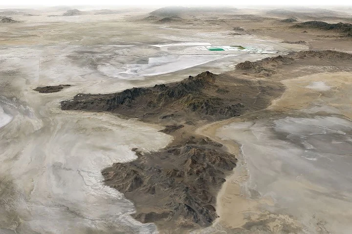
NASA scientists recently conducted field tests for the DAVINCI mission, which will study Venus, by using the dried lakebed of ancient Lake Bonneville in Utah. This site, marked by distinctive shorelines and salt flats, provided a unique terrestrial analogue for testing cameras and instruments designed to explore Venus’s mountainous Alpha Regio region.
What Happened
In June 2026, NASA researchers and engineers carried out a field campaign over Crater Island—a remnant island within the ancient basin of Lake Bonneville—to test the DAVINCI spacecraft’s imaging systems and scientific instruments. Suspended from a helicopter, the camera package captured hundreds of images of nearby rock formations to simulate the conditions the probe will encounter during its planned Venusian descent. The DAVINCI probe is scheduled to enter Venus’s dense atmosphere, where during a 60-minute descent it will capture near-infrared imagery and measure atmospheric chemistry.
Key Facts
Lake Bonneville was a vast Ice Age lake that began forming approximately 55,000 years ago, covering parts of present-day Utah, Nevada, and Idaho. At its largest, it rivaled the size of Lake Michigan. The lake drastically receded after a catastrophic flood about 18,000 years ago caused by the breach of a natural dam at Red Rock Pass, dropping water levels by more than 350 feet (105 meters) over six weeks.
Today, the remnants of Lake Bonneville include the Great Salt Lake, Utah Lake, and Sevier Lake, with expansive salt flats and playas rich in evaporite minerals such as halite and gypsum. These mineral-rich flats have enabled local mining activities, including potash extraction.
Crater Island, used for the 2026 field tests, comprises ancient sedimentary and igneous rocks and stands as an Earth analog to Venus’s Alpha Regio highlands. NASA’s DAVINCI mission will use the tested instruments to photograph Venus’s surface at a finer scale than Landsat’s orbital images of Earth.
What This Means
The field tests at Lake Bonneville represent a vital step in validating the DAVINCI mission’s technology ahead of its planned launch to Venus. By using Earthly geological formations analogous to those found on Venus, scientists can better prepare for interpreting the data the spacecraft will send back during its descent. This helps ensure the mission’s imaging and chemical measurements will accurately reveal Venus’s surface composition and atmospheric dynamics, advancing our understanding of Earth’s nearest planetary neighbor.
Furthermore, Lake Bonneville’s preserved shorelines and playas offer a natural laboratory not only for planetary science but also for terrestrial geology and history. The site’s flat salt flats have long been settings for engineering milestones like land speed record attempts, as well as being a historic landscape marking pioneer trails. Thus, this location continues to bridge Earth’s past with the exploration of other worlds.
Background
Lake Bonneville formed as volcanic activity rerouted the Bear River, causing water pooling throughout western Utah. Its dramatic draining event is one of North America’s largest known floods. The drying lakebed’s salt flats owe their formation to the evaporation of trapped water leaving behind mineral-rich crusts, which have been utilized for decades for salt and potash mining.
The DAVINCI (Deep Atmosphere Venus Investigation of Noble gases, Chemistry, and Imaging) mission aims to explore Venus’s dense atmosphere and surface features by capturing data during its descent, focusing on atmospheric composition and geology with near-infrared cameras and spectrometers.
What Comes Next
Following the successful Earth-based tests, NASA will proceed with final preparations for the DAVINCI mission’s launch, which will commence the spacecraft’s journey to Venus. Once in orbit, the probe will begin its atmospheric descent, collecting detailed data to unravel the mysteries of Venus’s surface and atmospheric chemistry.
Sources
This article is based on reporting and publicly available information from the following sources:
Read more Space & NASA stories on Goka World News.